Background

Pakistan is the world’s fifth most populous country, with an estimated population of over 220 million in 2022, and is projected to be the fourth most populous nation in the world by 2030. It is split across a handful of economic regions and shares borders with Iran, Afghanistan, People’s Republic of China, and India. The Arabian Sea, a part of the Indian Ocean, lies to the south. Disaster risks are a function of interplay among three key elements: hazards, exposure, and vulnerability
Risk is the likelihood of harmful consequences of natural hazards arising from the interaction among hazards, vulnerable elements, and the environment. Disaster risk depends on the probability that different kinds and intensities of hazards will occur, whether the elements are exposed to these hazards, and the level of vulnerability of the elements exposed to the hazards7. Risk information forms the cornerstone of any risk reduction agenda; thus, awareness of existing and anticipated risk is essential to guide DRR interventions, strategies, and policies.
Pakistan is a country that is highly vulnerable to natural hazards and resultant disasters, with a complex disaster risk profile that includes earthquakes, floods, cyclones, drought, landslides, and heatwaves. The country’s location in a seismically active region makes it particularly vulnerable to earthquakes, with the northern and western regions of the country at highest risk. The 2005 Kashmir earthquake, which measured 7.6 on the Richter scale, resulted in over 86,000 deaths and widespread damage to infrastructure and property.
Floods are another recurrent natural disaster in Pakistan, particularly during the monsoon season. The 2010 and recently 2022 floods were the worst in the country’s history, affecting millions of people and causing widespread damage to infrastructure and crops. Cyclones are also a threat to the coastal regions of Pakistan, particularly in the Arabian Sea, with Cyclone Phet in 2010 causing extensive damage to infrastructure and crops in Sindh and Balochistan. In addition to these acute hazards, Pakistan is also vulnerable to chronic risks such as drought, particularly in the arid regions of Balochistan and Sindh.
The 1999-2002 drought in Balochistan was particularly severe and led to widespread displacement of people and loss of livestock. Landslides and heatwaves are also significant risks, particularly in the mountainous regions and southern parts of the country, respectively.
  • The failure of governments to suitably prepare people for these hazards is a root cause of disaster. No matter the severity of the event, a disaster can be avoided. Framing natural hazards as a “natural disaster” deflects from the reality that vulnerability must exist before a crisis can emerge.
  • Climate change, poor land use practices, and forest and land degradation are exacerbating risks, especially the risk of hydrological hazards. The frequency and intensity of disasters is pushing the resilience and recovery capacity of communities, governments, and institutions to the limit. Climate change is now expected to increase disasters and lead to greater destruction in the future, with potentially profound implications.

Multi-hazard Risk Assessments and Cat Modelling of Pakistan

There have been several studies on multi-hazard disaster risk assessment in Pakistan, but it was never done at national scale using scientific baseline, tools and techniques, rather done at district and local levels (inselected ares by government or NGOs / INGOs), as stand-alone or part of any project activity / development plan / master plans of cities / towns. Moreover, these were always deterministic studies, and were unable to incorporate ‘what if scenarios’. Another factor that there was no expected loss and damage calculations in terms of financial / economic losses, as part of any assessment studies. Moreover, no attempt was made earlier for probabilistic risk assessment or catastrophe modelling for disasters originating from natural hazards. Catastrophe modeling can provide a comprehensive assessment of the risks associated with natural disasters in the entire region. By analyzing historical data, demographic information, and geographic features, catastrophe models can provide insights into the likelihood and severity of natural disasters such as earthquakes, floods, and cyclones.
Cat modeling at regional and global scales are available like CAREC for South Asia, which include Pakistan as well. These global and regional models are based on broader technical parameters and are being used for aggregated high-level information. The CAREC (Central Asia Regional Economic Cooperation) model is a comprehensive framework for regional economic integration and cooperation in South Asia. It focuses on improving connectivity, adopting an inclusive approach, delivering tangible results, promoting regional cooperation, and promoting sustainable risk sensitive development in the region. However, country-specific risk assessment and catastrophe modeling are crucial for several reasons:
Tailored to Local Conditions

Every country has unique characteristics that can affect the likelihood and impact of natural disasters. By conducting country-specific risk assessments and catastrophe modeling, policymakers and disaster management authorities can tailor their responses to local conditions and develop effective strategies for disaster preparedness, response, and recovery.

Accurate Risk Assessment

Country-specific risk assessments and catastrophe modeling enable accurate risk assessment of natural disasters. By analyzing historical data, demographic information, and geographic features, catastrophe models can provide insights into the likelihood and severity of natural disasters in a particular country. This information can be used to develop effective disaster risk reduction and management strategies.

Better Preparedness

Country-specific risk assessments and catastrophe modeling can help in better preparedness for natural disasters. By understanding the risks associated with different types of disasters, governments and disaster management authorities can develop emergency response plans, allocate resources, and conduct regular drills to ensure that they are ready to respond in case of a disaster

Improved Insurance Coverage

Country-specific risk assessments and catastrophe modeling can also help insurance companies to provide better coverage to the people of the country. By accurately assessing the risks associated with natural disasters, insurance companies can develop appropriate products that provide comprehensive coverage to people in the high-risk areas.

Investment Planning

Country-specific risk assessments and catastrophe modeling can help in investment planning for disaster risk reduction and management. The information obtained from these assessments can help governments and development partners to identify high-risk areas and prioritize investments in DRR measures.

Natural Catastrophe (Nat Cat) Modelling by SUPARCO - Pakistan

The CAREC Model or any similar global cat model cannot fulfill the specific requirement of Pakistan, but providing a base to build upon for next level of probablistic risk assessment. The extent and geographic pattern of earthquake, flooding, and infectious disease across Pakistan is revealed through probabilistic modeling, first time at national level in Pakistan, but also in first country-specific natural castrophe modeling in the region. Such modeling helps illustrate how natural phenomena interact with areas of high concentrations of population and assets to cause economic loss and damage in a particular scenario.
The NDRMF has engaged M/s SUPARCO to develop the Natural Catastrophe (Nat Cat) Model of Pakistan (Geo-referenced Exposure Database for Catastrophe Project for NDRMF). In the region, it is first initiative at national level. This Nat Cat modelling will assess disasters posed by natural hazards including hydro-meteorological (flood, drought, Tropical Cyclone) and Geo-physical (earthquake), in order to evaluate exposure and vulnerability of elements at risk and will quantify its financial impacts up to Tehsil (sub-district) level. The Na Cat modeling outputs include hazards, exposure, vulnerability and risk assessment against natural hazards (flood, drought, Tropical Cyclone and seismic) of varying frequency and magnitude on national level.

Nat-Cat Modelling - Scope of Work - SUPARCO

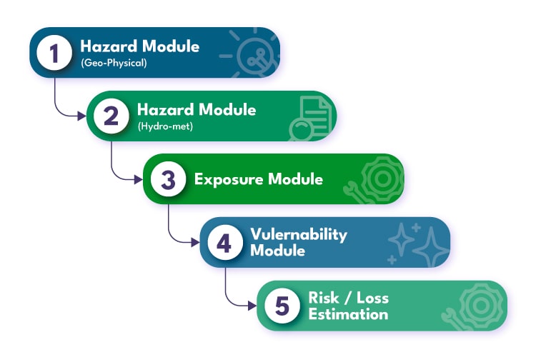
a) Development of a national spatial geo-referenced GIS dynamic database of public and private assets and infrastructure (agriculture, livestock, infrastructure, buildings, etc.) and associated physical vulnerability to different types of natural hazard of varying intensity and reconstruction costs.
b) Probabilistic disaster risk modeling and assessment for the quantification of the risk posed by:
geophysical hazards (earthquake)
hydro-metrological hazards (floods, droughts and tropical cyclones)
c) Capacity development of government staff in the collection, generation and utilization of exposure and disaster risk data and preparation of related protocols and manuals.
d) Development of an accessible, sustainable data platform, supporting use of the exposure and risk data by all relevant stakeholders.

The Nat Cat will help decision makers in prioritization of investments of public funds for structure and non-structure measures to be carried out by NDRMF and other relevant organizations with reference to NDMP 2012-22 and NFPP-IV. Additionally, it will provide baseline for entry / expansion of insurance industry in Pakistan market for disaster risk coverage. Finally, Nat Cat model will improve institutional capacities, performance and preparedness at key departments responsible for managing disaster risk in Pakistan. However, major limitations of the NatCat model include uncertainty in probabilistic hazard and risk assessment, non-availability of data of elements at risk (especially residential and commercial buildings, building structure type, materials etc.) at large scale along with spatial reference and building damage data against flood events.
Hazards, exposure and vulnerability assessment has been completed, and SUPARCO is working on probabilistic risk assessment. Based on the finalized risk module, the loss estimation module will be added. Work on web-based interactive risk calculator has also been initiated. Overall, 70% progress have been achieved on Nat Cat, and in few months’ time, it will be operational. For this diagnostic report, output of risk assessment and probable loss estimation specific to Pakistan will be added in due course of time.
Risk assessment module of Nat Cat is yet to be finalized, therefore, to develop this diagnostic report, information of hazard and exposure modules of SUPARCO are added here; and for the rest of information, regional studies and findings of similar Nat Cat models are refereed here in the report. The CAREC model is considered one of the most reliable model, and has recently (2021) produced risk profile of Pakistan, has been used to extract required information.

CONTACT US

CONTACT US

Stay Connected

Would you like to receive notifications on latest updates? No Yes